Educational Adventures in Arizona

Wednesday, February 14, 2007

ASH FORK ~ February 11, 2007

Ash Fork is located in northern Yavapai County at the junction of State Highway 89 and Interstate 40, along Historic Route 66 which runs the length of the town. A large monument in the center of town tells about the history of Ash Fork. For many years, stage coaches headed for Prescott started from here. Visitors can see some businesses here that have been in operation since the 1920’s - and from our more recent past, a computer store on the corner in which you can still see a big poster in the window announcing “Welcome to the World of Windows 95.” Ash Fork was named for the ash trees that grew on the town site. Today, Ash Fork is known as the Flagstone Capital of the United States. Elevation: 5,128 feet.

The original transcontinental railroad line that the Atlantic & Pacific constructed in the 1880’s became part of the Santa Fe Railway’s main line connecting Chicago and California. Like the Beale Wagon Road, the Arizona section of this railroad generally followed the 35th parallel in crossing the northern part of the state. The northern Arizona towns of Holbrook, Winslow, Flagstaff, Williams, Ash Fork, Seligman, and Kingman owe their existence to this railroad. The railroad dominated the economy and served as a lifeline to civilization for the towns along its route, which were otherwise isolated settlements in the middle of the wilderness.

Labels: , ,

BEALE WAGON ROAD ~ February 11, 2007


We were driving down Route 66 from Kingman to Seligman, through the little towns of Hackberry and Valentine. Just before Truxton, we got off on a side cattle road to have a picnic lunch. It was a grassy area with rolling hills, and we didn’t see any cattle although a herd of pronghorn was grazing nearby. The railroad runs parallel to Route 66, and we stopped just before we got to the track. While we were there, several freight trains passed by. After lunch we walked down to the tracks and waited for another train to come by. We waved at the engineer, and he blew his whistle and put his hand out the window to wave back at us.

The dirt road that we were on ran alongside the railroad tracks, and we decided to drive that way for a while because we thought it might lead us to Truxton. It didn’t, but we made an exciting discovery. Along the dirt road there were BLM markers that said “Historic Beale Wagon Road 1857-1883 BLM AZ Heritage Project 1993.” Suddenly it all made sense! The modern-day roads and development followed these historic trails, of course, over which people had traveled through the centuries and built up towns along the way. So if you go all the way back to its original beginnings, Route 66 was even more historical than we thought. It was so cool to think we were traveling on the same path that wagons had traveled on in the 1800’s.

After we got back home, I did a little research on the Beale Wagon Road. In the late 1850’s, Lieutenant Edward Fitzgerald Beale and his party of men set out on a route along the 35th parallel to construct a wagon road from Fort Smith, Arkansas to the Colorado River. Beale’s road roughly followed Lieutenant Amiel Whipple’s trail west across Arizona. They took a detour around Canyon Diablo, continued on through the Flagstaff area, headed northwest through Peach Springs and Truxton Wash (named for Beale’s son), then through Kingman and on to the Colorado River. Portions of this historic trail are still visible near the Navajo community of Leupp, at Laws Spring northeast of Williams, and between Valentine and Peach Springs.

This wagon road was once the major “interstate highway” across the northern Arizona Territory during the 1860’s - 1870’s. It traversed deserts, forests, and prairies. Deer, elk, and pronghorn antelope were commonly seen along the way – and they’re still there, as we observed. Modern roads, most notably Route 66, indeed followed the Beale Road alignment. Two of the best preserved original stretches of the Beale Wagon Road are northeast of Williams - the open grasslands of Government Prairie and dense pinon-juniper woodlands near Laws Spring. From Laws Spring, hike about 1/4 mile south and east along the marked trail to discover a segment of the original road that appears as two rows of rocks about a wagon-width apart.

http://www.southwestexplorations.com/bealemap.htm - Beale Wagon Road Navigation Map. (See also: http://www.tomjonas.com/swex/beale.htm)

http://www.fs.fed.us/r3/kai/recreation/trails/wil_beale.shtml - Printable map of Beale Wagon Road Historic Trail #31, from the U.S. Forest Service.

http://jan.ucc.nau.edu/~rse/riordanrt66.htm - Route 66 and Northern Arizona: Presented at the Riordan Mansion Brown Bag Lunch Sessions on June 13, 2000.

Did You Know…? Beale is most remembered for using camels in his road-building expeditions. Camels can travel for days without water, they eat more types of forage than mules do, and they can also carry heavier loads than mules. Beale’s camel driver, Hadji Ali (Hi Jolly), later lived in western Arizona. Ali's grave in Quartzite is marked by a stone pyramid topped by a copper camel.

Labels: , ,

HISTORIC ROUTE 66 ~ February 11, 2007

U.S. Highway 66 (aka “The Mother Road” and “Main Street USA”), established in 1926, covers a distance of 2,300 miles from Chicago to Los Angeles. During the Great Depression in the 1930’s, thousands of families emigrated from the Dust Bowl to fertile lands of California by way of this road, most of which was unpaved at that time. Paving was completed by 1937.

After World War II, Route 66 became the scene for glamour and adventure, enticing many to travel and experience the life of the open road. In the 1950’s, Route 66 became popular with families taking cross-country trips and vacations to the scenic Southwest. The popularity of automobile travel coincided with the rapid expansion of independently owned roadside motels, trailer courts, gas stations, souvenir/curio shops, and drive-in restaurants.

Route 66 and its attendant structures pretty much fell by the wayside with the advent of Interstate 40, when high-speed travelers became more interested in making good time than in having a good time. The last active piece of Route 66 near Williams, AZ was decommissioned in 1986. Today, Route 66 attracts nostalgic visitors seeking to recapture that old spirit of adventure and fun while enjoying Arizona’s classic scenic beauty.

The longest remaining continuous stretch of the original Route 66 is located right here in Arizona, running from Topock to Ash Fork. On this trip we had already traveled the portion from Topock to Oatman and Gold Road. From there we continued on through Kingman, Hackberry, Valentine, Truxton, Peach Springs, Seligman, and Ash Fork. It was a really nice drive off the beaten path, one of the most enjoyable routes we’ve ever taken. Once we left Kingman it was like we had the whole road to ourselves, so it was the perfect place for our 16-year-old student driver to obtain miles of experience – no mountains on this part, either, just rolling hills and sweeping vistas across far-reaching plains.


Things to See Along the Way:

Hackberry General Store, Hackberry School, Valentine Indian School, Little Red Valentine Schoolhouse (Mile Post 86), Valentine Post Office Ruins (Mile Post 87), Hualapai Indian Nation, Grand Canyon Caverns (Mile Post 115), Seligman Barber Shop/Route 66 Museum, Snow Cap Drive-in, Ash Fork Monument.

http://www.route66giftshop.com/main.html - Angel Delgadillo and his brothers and sisters grew up watching the traffic flow by on America's Main Street, starting with the folks from the Dust Bowl Era driving by in their automobiles full of everything they owned. It was an amazing caravan of poor folks heading west, seeking opportunities to better their lives.


Labels: , , , , , , ,

GOLD MINE TOUR ~ February 11, 2007


Located 2½ miles east of Oatman, AZ on Historic Route 66, the Gold Road Mine offers tours to the public. It’s open daily from 10:00 am to 5:00 pm. We were there bright and early on a Sunday morning for the first tour of the day. We were the only ones there at that time, too, which was great because our family had the tour all to ourselves and it was like we had our own personal tour guide. He was a great guy, too, and we gave him a tip afterwards which he obviously appreciated. The basic one-hour tour is $12 for adults and $6 for kids 12 and under. Group rates are also available at $11.00 per person for groups of 10 or more.

The Mine Tour is a walking tour, but transportation is available for the physically challenged. First, you will meet a nice lady in the main office. You are required to wear a hard hat and sign a liability waiver. Have your kids go to the bathroom there before you head up to the mine. For the tour, you will be transported in a tractor-like vehicle up to the mine entrance. The guide will take you into the mine approximately one-eighth of a mile. The mine is well-lit and there is safety fencing blocking off certain areas. You are invited to bring along your camera or camcorder and take as many shots as you please.

Going into a real underground gold mine was an exciting experience, and the tour guide was interesting and informative. He helped us to imagine what it must have been like in the old mining days. He shows you side shafts, mine cars, an elevator, a “widow maker” drill and other equipment that they used. At one point you can gaze down into a 1,400 ft. deep dark pit, but the wire fence was bowed out from people leaning on it to get a good look, so you wouldn’t catch me getting too close! About half way through the tour you will be standing directly under Route 66, which is a good picture-taking spot. Then the guide takes you into the original “Glory Hole” where you can see the gold-filled quartz veins. We even got to see a real tectonic plate that was exposed and lines one side of a shaft – it looks like a large flat smooth slab of rock.

Hard-rock miners worked three shifts a day, drilling, blasting, and hauling. Then the ore would be soaked in cyanide to extract the gold. Some quartz veins contain a higher percentage of gold than others, and the lesser quality veins are left in place because it’s just not worth the trouble to dig them out for such a low concentration of the yellow metal. At the end of the tour they let us take a bunch of ore samples home – which in itself was worth the price of the tour for us rock hounds!

It was in 1900 when a Mexican prospector named Jose Jerez was out searching for his lost burros. He stumbled over a chunk of quartz that glistened brightly in the midday sun. Upon examining the rock, Jose saw that it contained some gold. He took it in to have it assayed and it came out to 40 ounces per ton. Some investors purchased his claim, which then changed hands several times. By the end of 1907, the Gold Road Mine had reportedly produced 140,625 ounces of gold worth $2,250,000.00. Since then, the Gold Road Mine has been in production on and off now for about a hundred years.

During World War II, the government needed other metal types for the war effort, so the miners were taken to other areas and the Oatman mines were closed. The Gold Road Mine was re-opened in 1995 and it produced about 40,000 ounces of gold annually until the market price of gold dropped in 1998. Production costs alone were $271 per ounce, so most of the workers were laid off and moved away while the gold in the mine awaited a better day. A few employees stayed behind to provide these great mine tours. We were told that the mining company recently invested in some new equipment and may be getting ready to gear up production again once the gold price is right.

Visit www.goldroadmine.com for details on the Gold Road mine tour. Also click on “Mine Safety” for important information about the hazards of abandoned mines – a must-read if you plan on exploring the area. Curiosity can be deadly when it comes to old mines. So if you’re tempted to venture into a real gold mine, do it safely and enjoy this exciting guided tour.

Labels: , , , ,

A HAUNTED HOTEL AND A MYSTERIOUS CAR ~ February 11, 2007

The Oatman Hotel is listed on the National Registry of Historic Buildings. It has 10 rooms and is the only two-story adobe building in Mohave County. The Gable/Lombard Honeymoon Suite has been refurbished to the period when Clark Gable and Carol Lombard stayed there. The legendary Hollywood couple often returned to the place where they spent their wedding night in 1939. It is said that guests and staff can sometimes still hear the pair whispering and laughing in that room.

The ghost of “Oatie,” an Irish miner, is also said to haunt one of the guest rooms. One time a professional photographer took a picture of the empty room, and a ghostly figure appeared in the developed print. We were able to peek inside those two rooms, but most of the others were closed. The rooms were small, the bathrooms were down the hall, the furnishings were antique, and the floor was creaky, but we didn’t sense anything spooky. Quite the opposite, it seemed pleasant and I kept thinking how the place must have been pretty lovely and lively in its former life.


Although we didn’t see any ghosts, a strange thing happened to us while we were in Oatman. There was an old car – an Edsel I think – painted primer gray with whitewall tires and a historic vehicle plate. That car seemed to appear and re-appear everywhere we were. We were joking amongst ourselves saying that it must be the phantom car of Oatman or something. The driver always stayed inside the vehicle and all I could see was a shadowy figure dressed in black. Later on at home when I was telling my mom that story, she suggested the possibility that he may have been stalking us. So that got me to wondering, and gave me a creepy feeling when I started thinking about it.


Since we had camped in the area overnight, we arrived in Oatman way early in the morning before the shops were open, so it was kind of neat that we had the place all to ourselves before the tourist crowd arrived. We walked up and down Main Street, then visited the hotel. The first time we saw this unusual car, it was parked off to the side at the top of the street. Then when we were standing in front of the hotel, I asked Rich if he could walk down the street a ways to take a picture. The minute Rich walked away, that car started up, made a u-turn, and pulled up right next to our three boys. I was standing on the other side of a big post so I still didn’t see the driver. Rich had snapped a quick picture and came running back so he wasn’t gone very long and we walked away.


Soon after that, we got in our car and left Oatman, but we decided to stop at a gold mine on the outskirts of town. Oatman is located on a desolate mountainous part of old Route 66, and after leaving town the road starts winding up the mountainside. When I looked back to see Oatman one more time, I noticed that the old car was also leaving town in the same direction that we were going. Well, we decided to stop at a gold mine on the outskirts of Oatman, and when we were stopped at the gold mine I saw that car going up the mountain road past us. So it should have been long gone by the time we got out of the one hour gold mine tour, right? Well, after the tour we got back on the road, continued on up the mountain, came around a corner, and there it was! It was parked up at the top of the hill above the mine, as if waiting and watching for someone (us?) to come by.

Now that was uncannily reminiscent of Steven Spielberg’s “Duel” thriller starring Dennis Weaver. In that movie, a mysterious truck with an unseen driver kept following him and trying to run him off the road, which was in a desert canyon country just like this. I kept watching for that car the rest of the day expecting it to turn up again somewhere, but once we left the Oatman area I never saw it anymore. It did show up in one of the photos that we took, though! Hmm, I think that scenario would make for a good imaginative story starter.

Bu the way, the road from Oatman to Kingman is steep and narrow with several sharp hairpin curves, not suitable for vehicles over forty feet in length. The road to Oatman from Topock is not nearly as steep and doesn’t seem like it would be as dangerous, although we saw more roadside crosses between Topock-Oatman than we did on the Oatman-Kingman road. Please drive carefully!


http://www.oatmangoldroad.com - Oatman-Gold Road Chamber of Commerce

Labels: , ,

OATMAN ~ February 11, 2007

Oatman is an authentic western town of the style that is often copied by movie studios – a row of buildings on each side of a main street lined with wooden sidewalks. The town was named in honor of Olive Oatman, a girl who was kidnapped by Apaches after they massacred her family. The Apaches sold her to the Mojave tribe, where Olive lived for several years until she was rescued in 1857 near the site of the town. In its heyday from the early 1900’s to the 1940’s, Oatman was the largest producer of gold in Arizona, and once was home to thousands of residents. In 1930 the town boasted two banks, seven hotels, ten stores, and twenty saloons.


Route 66 had been built in the 1920’s, and after the mines closed down the town hung on, catering to the many travelers on the road. At first those old Ford Model A’s and Model T’s had to make the treacherous climb up Sitgreaves Pass and down several hairpin curves to Oatman. But in 1952, Route 66 was shifted to an easier more southerly route which bypassed Oatman and went through Yucca so cars could avoid the steep, narrow mountain road. Then when Route 66 was replaced with the I-40 interstate, Oatman suffered a final devastating blow. Today it supports only about 100 people year-round. Oatman is now a tourist town with gift shops and restaurants, since the historic Route 66 has became a popular destination for travelers from all over the world.


For years we’ve heard about the wild burros roaming the streets of Oatman but we didn’t see any when we were there! Apparently they had been there recently, though, because we had to watch where we were walking so we didn’t step in anything. In the afternoon there are supposed to be shootouts between costumed gunfighters in the middle of the main street, but we were there first thing in the morning so we didn’t see them either. Even so, it was well worth the visit to this photogenic old town and we got to go inside the “haunted” Oatman Hotel.

Labels: , ,

Tuesday, February 13, 2007

PARKER/LAKE HAVASU ~ February 10, 2007


After leaving Swansea, this time we headed west at the four-way stop to Shea Road and Parker. It was actually a better, faster road than the one from Bouse. Parker has a historic AZ & CA Railroad Depot with old coach cars on display. The gasoline prices seemed to be a lot cheaper in Parker compared to other places – perhaps a ploy to get Californians to drive over to buy gas? We drove across the river and back again for what the kids called our “30-second California vacation.” We drove up to Parker Dam and passed over the Bill Williams River where it flows into Lake Havasu. It’s hard to believe it was the same river that we were picnicking at upstream. The river was so much wider here and swamp-like due to the lake water backing up into it. There are some nice state parks along there, as well as a national wildlife refuge. But we didn’t stop because we were making good time and were eager to get through Lake Havasu City so that we could find a camp site before dark.

When we were passing through Lake Havasu City, a lady pulled up next to us at an intersection, honked, and pointed to our front tire which was totally flat and we hadn’t even noticed. We drove around for a while looking for a gas station – which of course are on every corner except when you really need one! Then Rich wondered if there was a Discount Tire in that town. Almost as soon as he said that, he spotted what looked like a Discount Tire sign down the road as we were turning right at an intersection, so we turned back around and went that way and sure enough, it was a Discount Tire store. But it was going to be closing in just five minutes! Even so, they cheerfully took us in and checked our tires, and the rear tire was flat, too. I thought it may have been from a sharp rock on our off-road escapade, but in fact both tires had nails in them. I guess we must have picked them up in the ghost town? Rich has road hazard insurance with Discount Tire so that was good; and we were so thankful that those guys were willing to help us at closing time. We were lucky, too, because we would have been in bad shape if that nice lady hadn’t honked at us and we had gone camping in the middle of the desert that night, then woken up to discover that we had two flat tires and only one spare! We had a guardian angel watching over us I think!

That pit stop had put us behind on our time, but at my request we took a little detour so we could say that we had driven over London Bridge. Then we continued northward on I-95 which veered east a little bit, so when we got to I-40 we had to head west. Topock was a strange little place with a bunch of white pipelines stretching over a narrow part of the river, adjacent to the same spot where an old bridge on Route 66 entered California. It looked like I-40 climbed up a hill toward the sunset on the other side, while we got off and went north to Golden Shores. It was a tiny little town with one general store, a pizza/ice cream shop that was closed, a liquor store/gas station and a fire station. That area felt dark and isolated, but not as lonely as we were going to get later. Everywhere else we go in the state, there are either cattle roads or forest roads that we can camp along. But do you think we could find a side road to get off on? We drove and drove, and there were all these weird little circular turnouts on the side of the road but no dirt roads that went anywhere. We were speculating as to whether those turnoffs were something left behind from the busier days of Route 66 perhaps. Finally when we started getting near the mountains we found a dirt road with a maze of others leading away in different directions, probably branching off to old mines. The whole area seemed abandoned, and there wasn’t another soul around. Yet way down across the plain to the West, we could see the twinkling lights of a city – Needles maybe, or Bullhead City?

Labels: , , , , , , , ,

SWANSEA TO BILL WILLIAMS ~ February 10, 2007


We like to visit ghost towns to learn about Arizona’s history and get a glimpse of what life might have been like in past times. Unfortunately, other people apparently go there just to take advantage of the remote site and have a good time. There were a bunch of RV’s parked on one side with dune buggies riding around on the mine tailings. On the other side was a caravan of RV’s arranged in a circle around the site’s public restroom as if to claim it for their own personal use. I don’t think that’s very nice because the restroom is intended for the use of all visitors, not just them. And who would want to park so close to a stinky outhouse in the first place? The sound of dune buggies and ATV’s gets kind of annoying when you’re trying to immerse yourself in the history of a place. Here we are traveling to the middle of nowhere to get away from civilization, while other people are bringing civilization along with them wherever they go! In a quest to find peace and quiet, we drove through the town and continued on a jeep trail which was supposed to lead to the Bill Williams River (named for an Arizona mountain man who used to live in the area) and the remains of a pumping plant that brought water through a pipeline to the townsite.

This area off the beaten path is accessible by a high clearance four-wheel drive vehicle. You will find yourself literally driving along sandy and gravelly wash bottoms through a dramatic canyon. Route-finding is fairly easy but this jeep trail is not recommended for inexperienced drivers. We’ve been four-wheeling since our Bronco II days in the early 1980’s and this was one of the tougher roads we’ve been on. It has a combination of rough rutted dirt surfaces, steep rocky places, deep sand and gravel, narrow sections with drop-offs, and tight clearance. Wash crossings may have mud and water if it’s rained recently. Certain sections may cause traction problems. Flash flooding is possible in places, and even in winter we got hot and were glad to take a dip in the river, so this trip is definitely not recommended during rainy seasons or in the heat of summer.

A friendly old guy and his dog were coming back up from the river on an ATV and the guy seemed amused to see us going down there in our big SUV. Although he left the area, he doubled back later, perhaps to check and see if we were able to make it out okay. The river and both sides of the canyon are part of the Swansea Wilderness, which is closed to motor vehicles. You will have to park at the boundary sign and walk to the river (approx. 100 yards). The pumping plant was located on the east side of the canyon where it joins the river. Supposedly if you climb up the cliff you will be able to see the old remains (the ATV guy said it’s basically just a concrete slab), but we were having too much fun picnicking at the river so we didn’t bother doing that. The river was running nicely when we were there and it was safe for even the littlest child to wade in, but the water must rage through the narrow rocky canyon dangerously at flood times. In the distance we could hear the braying of wild burros, descendants of those brought by long ago miners. When the mines were shut down, the burros were set free to roam the hills. We saw some burro trails but never did see the actual animals.

After we came back from the river, we drove around the Swansea townsite once more before leaving the area. We had stopped to look at a ruin that just happened to be next to a four-wheel drive road that went down to the old railroad grade, but we had had enough four-wheeling for one day so we were going to turn around. But before we had a chance to, some guy who was sitting nearby in a lawn chair next to a trailer came running over with a beer in one hand and told us that we shouldn’t go that way because “you won’t get down there without a four wheel drive.” My husband graciously thanked him and told him that we did have a four-wheel drive vehicle but we weren’t planning on going that way anyway. Hmpfh! If only that guy knew where we had just come from! What do we look like, yuppies?

We didn’t get the Ford Expedition XLT with off-road package for driving around town, that’s for sure! We’ve always been a 4X4 family, having progressed from a Bronco II to a Ford Explorer and finally an Expedition as our family has grown. The Ford Expedition is a great vehicle, by the way, if you’re looking for a large go-anywhere vehicle that is comfortable, kid-friendly and rugged. The 4x4 Off-Road Package provides skid plates for the underside of the vehicle. It also includes black tubular steel step bars, fog lamps, special shocks, and all-terrain tires. It's too bad that SUVs are falling out of favor these days due to soaring gas prices, because some of us really do need the extra room, off-road capability, and heavyweight towing capacity that a full-sized truck-based SUV has to offer. Whether you live on a rural homestead or if you are planning a cross-country expedition – or if for any other reason you may need a large vehicle that has room for lots of people and their stuff, as well as good off-road ability and heavyweight towing capacity – the Ford Expedition is hard to beat!

Labels: , , , ,

SWANSEA, AZ ~ February 10, 2007


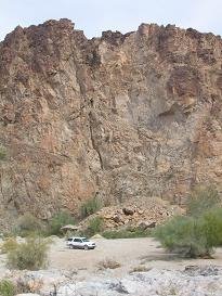
Swansea is an abandoned copper mine and ghost town in the Buckskin Mountain area of LaPaz County. It’s a unique, large and interesting site that can be accessed without 4-wheel drive. Bring plenty of food and water because the mountainous desert area surrounding Swansea is in the middle of nowhere with no services or signs of civilization, and cell phones don’t work there either. Even though its location is remote with limited access, the place is no secret and it’s a popular destination. The best time to go is in winter when the weather is mild. Elevation: 1,280 ft.

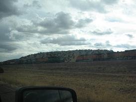
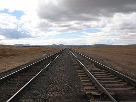
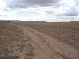
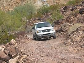
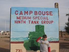
The road to Swansea starts in Bouse, AZ at the Camp Bouse memorial on Hwy. 72. We turned right on Main Street, went past an assay museum, and turned left on Rayder Ave. which turned into Swansea Rd. Just outside Bouse there is a fork in the road at which point you will want to bear left. After that there are three main landmarks. You will cross the Central Arizona Project (CAP) Canal, then you will come to a point called Midway that has an interpretive kiosk. Midway used to be a water stop on the railroad line that connected Bouse and Swansea. From there you will veer left, and after that you will come to a four-way stop sign. Turn right to get to Swansea. Just before arriving in Swansea, if you use your imagination you will see a dark brown mountain shaped like a gorilla’s head, which we called Gorilla Peak. Drive around the back of that mountain and you will soon see the ghost town. The curvy mountain road going down to Swansea is a little narrow and scary, but several RVs had made it down there.

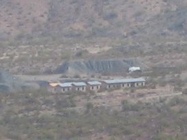
Originally a 21-mile buckboard ride from Bouse, Swansea was the headquarters for the Clara Consolidated Gold and Copper Mining company. The town was named after Swansea in South Wales, UK where the original stakeholder George Mitchell came from, and where most of its copper was shipped. The Swansea site covers an extensive area. There are a number of buildings still standing, mine shafts, a main street, a railroad station, and ruins of the smelter. The mine was active periodically from 1908 to 1949. It produced 27,000,000 pounds of copper. The ore was shipped by railroad to the Colorado River, transferred onto river steamers headed to the Gulf of California, then by freighters around Cape Horn to Swansea, Wales.

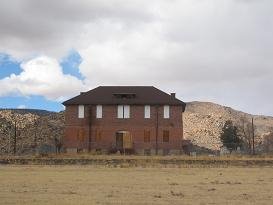
Swansea's post office was established on March 25, 1909 and was discontinued on June 28, 1924. During its heyday, Swansea’s population grew to a total of 750 residents, mostly men. It was not as large as Jerome, Oatman or Bisbee. Swansea had an electric light company, auto dealer, lumber company, two cemeteries, a saloon, moving picture house, general store, insurance agent, justice of the peace, “Swansea Times” newspaper, railroad station, Mitchell’s two-story residence, and of course the mine and smelter. Swansea’s population declined when copper prices dropped after WWI. In 1929, the American Smelting and Refining Company rebuilt much of the town. However, due to the Great Depression the mine was closed and Swansea became a ghost town in 1937, although periodic mining did continue until 1949.

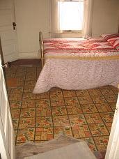
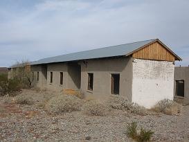
Imagine our surprise when we came around the mountain and got our first glimpse of Swansea. Instead of dilapidated shacks, we observed sunlight reflecting off shiny metal roofs! As we drove closer, we saw that the rafters were built of fresh lumber. Hmm, was this a ghost town or a construction site? Both I guess, because the row of old miner’s shacks are in the process of being restored. The roofs had caved in over the years, and without any protection from the elements, the adobe and stucco walls would start wearing away. The old wooden floor boards are also being replaced. We got to see one shack that was pretty well remodeled, but also got to see some that still had the original wood floors and ceiling timbers remaining. I’m glad to see that these old structures are being preserved for future generations to explore. I wonder how the miner’s shacks managed to last as long as they did? Because all that’s left of the other structures are cement foundations or ruins. How can the brick walls of a smelter fall down anyway? And there’s nothing left of the two town cemeteries either because the graves have all been dug up. What’s the deal with that? Don’t people have any respect for the past, not even for the dead?

The Swansea site is much larger than it first appears once you learn about the area. The Bureau of Land Management provides brochures that enable visitors to understand and appreciate the site. There is an information kiosk with a brochure holder where you first enter into Swansea, but it was empty when we arrived. You may be able to get a brochure in advance at the BLM Field Office in Lake Havasu City. We found and printed out an informative brochure and map of Swansea online:
http://personal.riverusers.com/~fw/AGT/swansea.htm.

You can view some more beautiful photos of Swansea here:
http://www.ghosttowngallery.com/htme/swansea.htm

Labels: , , ,

Monday, February 12, 2007

BOUSE, AZ ~ February 9-10, 2007

When Rich got home from work on Friday the 9th, we had some quick subs for supper while we loaded up the car, and we took off to get a head start on our weekend road trip. We drove through Wickenburg and past Salome on Hwy. 60. We weren’t sure how far we were going to get that night, but we made it all the way to Bouse on Hwy. 72. We got off on a dirt road that crossed the Bouse wash, but we didn’t get too far from the highway because it got real sandy and we were afraid we’d get stuck. So we had to listen to highway sounds all night, surprised at how much truck traffic was traveling back and forth between Parker and Bouse. Hwy. 72 also paralleled a railroad track, and in the middle of the night I was awakened by the sound of a passing train that was so loud, I could hear the squeaking and groaning of each freight car as it went by. The next morning we took down our tent as the sun was just appearing from behind the mountains, explored the sandy wash for a bit, and headed in to Bouse where we had seen a sign that said “$2.99 Breakfasts.” Sure enough, at Coachman’s Café we were able to order either pancakes, scrambled eggs and diced ham, or French toast for only $2.99 each. The food was good and it was a nice restaurant, too, apparently popular with the locals because everyone else seemed to know everyone there. The customers were mostly senior citizens, with some cowboy-looking characters and a group of men wearing WWII hats.


It just so happens that we were in Bouse on the second weekend of February, at which time they hold an annual WWII Camp Bouse dedication and reunion. Camp Bouse was a secret army base located 20 miles east of Bouse in the remote Butler Valley, where men were trained to use a special new tank designed for night warfare. There is a Camp Bouse memorial monument located on Hwy. 72, across from the A & C Mercantile Co. It’s a great memorial with real tanks and other army vehicles on display, and several bronze plaques to read. The people were setting up for their festivities while we were there, so we also got to peek into a canvas tent where they had exhibits of WWII uniforms and other artifacts on display. I would have liked to have seen the old Camp Bouse where they were going to be having tours, but we had to be getting on our way if we were going to get to all of the other places we had planned on.

Labels: ,

Swansea/Oatman/Route 66 ~ February 9-11, 2007

Traditionally we like to take a Valentine’s Day trip, and since Valentine’s Day was on a Wednesday this year we decided to go on the weekend before. We’d been wanting to visit Oatman and the ghost town of Swansea for a long time, and ever since getting the Pixar “Cars” movie for Christmas, we’ve been interested in Route 66. So this was going to be our ghost town/Route 66 trip. While it may seem like ghost towns and Valentine’s Day don’t really go together, we did visit the honeymoon suite of Cary Grant and Carol Lombard, plus we got to drive through the town of Valentine, AZ!

Labels: , ,